Over one hundred years ago almost every American and European astrologer set up a Speculum when examining charts. The technique greatly facilitated work with progressions and directions done, as they did them, in mundo. Because no computers were available, the work was long, tedious and prone to error. Today, with a copy of Solar Fire, an astrologer may quickly set up an accurate Speculum. One should not be intimidated by the amount of information listed by a Speculum; you can always find information that will actually help you in your work.
The examples used in this Section are Tom Brady, August 3, 1977 at 11:48 am PDT in San Mateo, CA and his marriage to Gisele Bündchen on February 26, 2009 at 5:55 pm PST in Santa Monica, CA.
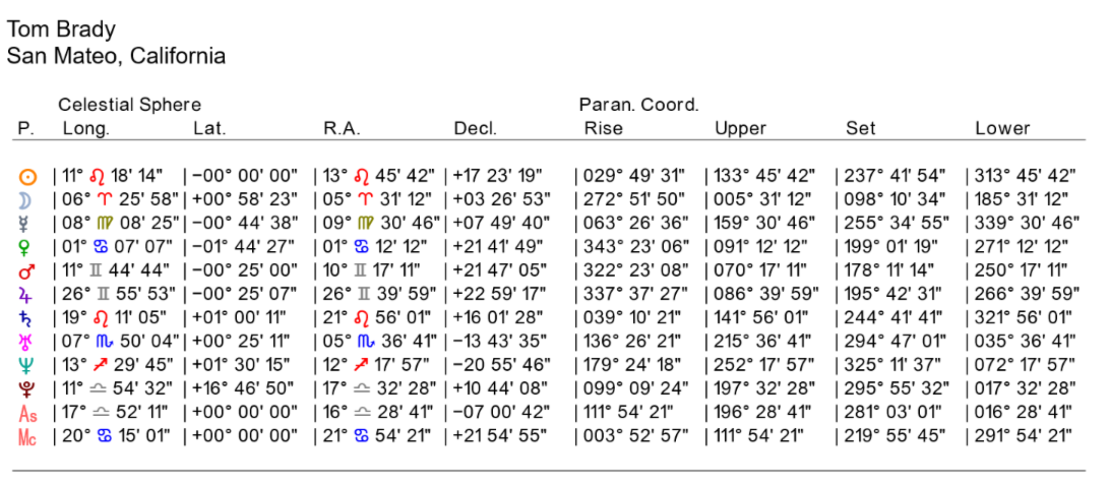
There are several tables that make up a Speculum. The first part of table 1 (above) shows Tom Brady’s Zodiacal planetary positions in the Zodiac (Long. and Lat. for Longitude and Latitude) and along the Equator (R.A. and Decl. for Right Ascension and Declination). The second part, labeled Paran. Coord. (for Paran Coordinates) list the positions of the planets projected on the Equator in degrees when each one Rises, crosses the Upper Meridian (MC), Sets and crosses the Lower Meridian (IC).
The first table of Solar Fire’s Speculum are the General Coordinates. The natal chart name and location identify the table. The first part of the table is a section labeled Celestial Sphere. Planet labels are listed on the left followed by a column labeled Long. This column lists the planetary positions in Zodiacal Longitude using degrees, minutes and seconds in the signs. The next column is labeled Lat. and lists each planet’s Zodiacal Latitude (distance North or South of the Ecliptic in degrees, minutes and seconds). Longitude and Latitude are the two coordinates used to describe positions of planets with respect to the Ecliptic. The next two columns describe the planets positions with respect to the Equator. The longitude-like, left-right measurement along the Equator is called Right Ascension and the column is labeled R.A. The North/South-like coordinate of the Equatorial System is called Declination and the table labels this column Decl. These first four columns describe the familiar longitude and latitude coordinates along with the right ascension (RA) and declination (Decl.). It is the declinations which let the astrologer determine which planets are in parallel or contra-parallel aspect and is synonymous with terrestrial Latitude.
The next four columns are labeled Paran. Coord. For Paran Coordinates and are given in degrees, minutes and seconds from 0° to 360°. These are the Right Ascensions of the MC (RAMC) for the angle transits (passing over the local Horizon) of the natal planets and luminaries. Note that while the Moon, for instance, moves in longitude (etc.) between rising and culmination, the natal Moon is fixed in a particular coordinate (be it Longitude, RA, Declination, etc.) and only the axial rotation of the Earth is involved in rotating the natal planets to and through the angles that are defined by the Meridian and Horizon planes.
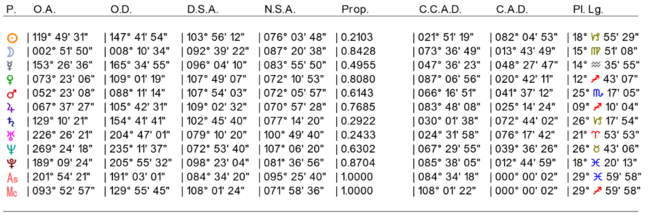
The second Speculum table lists various motions of the planets as they rotate around the Earth.
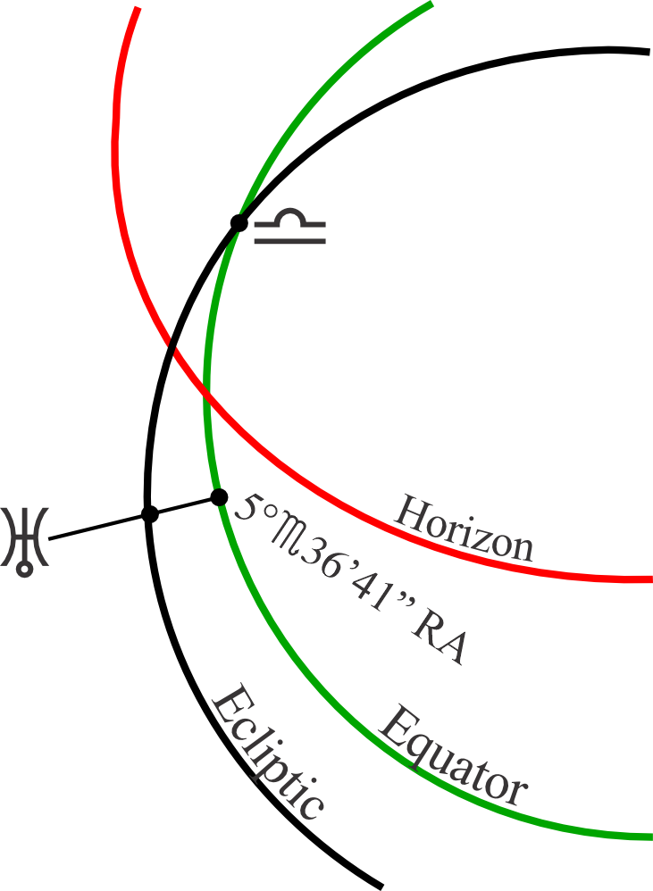
The OA (Oblique Ascension) of a body is expressed in RA (Right Ascension). When a celestial body (like a planet or fixed star) stands on the Horizon, where the Equator simultaneously crosses the Horizon is the factor’s Oblique Ascension. The Oblique Descension is the same thing calculated for when the body sets in the west. OA and OD are "oblique" because planets rising and setting across the horizon do so at on oblique angle almost all the time.
 |
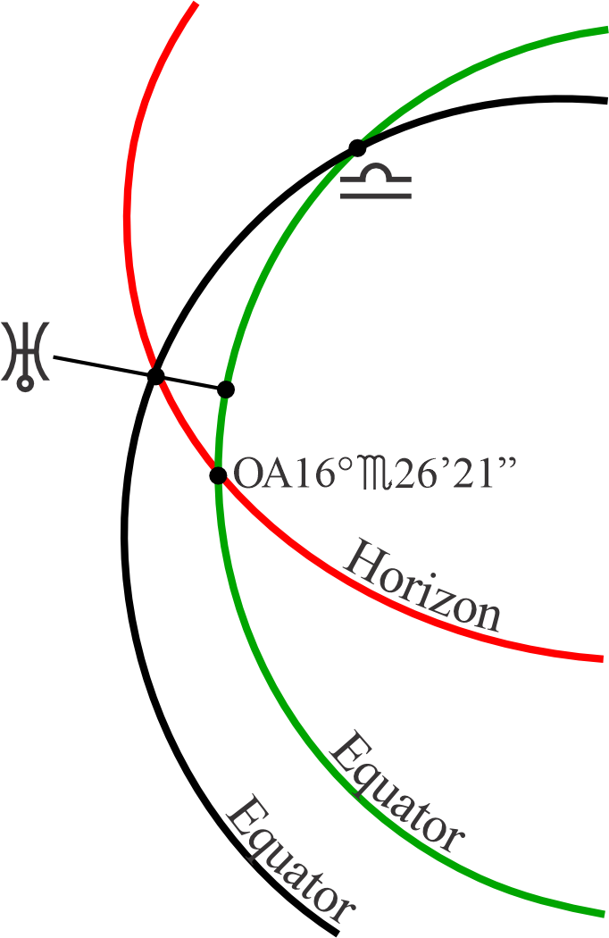 |
Tom Brady’s natal Uranus on the left illustration stands at 7°x50’4” on the Ecliptic which equals an RA position of 5°x36’41”. When we rotate the celestial sphere to bring Uranus to the Horizon, the degree where the Equator now crosses the Horizon at the same time is the position of Uranus’ Oblique Ascension (OA) also expressed as an RA of 16°x26’21”. Wherever the Equator and Horizon cross in the East is the East Point. To create the Oblique Descension we would continue to rotate the Uranus till it crosses the Horizon in the West. Where the Horizon crosses the Equator in the West at the same time is the OD for our Uranus example.
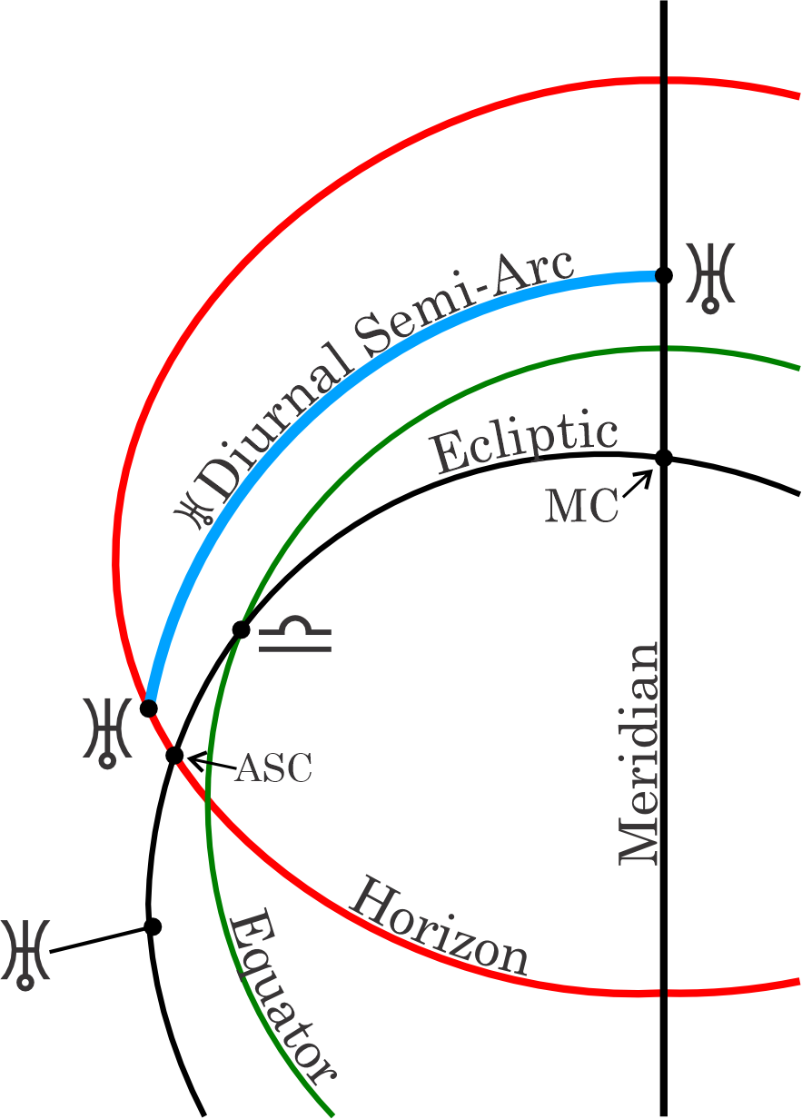
Because the Ecliptic is tilted with respect to the Equator, when Ecliptic planets or fixed stars rise from when they cross the Ascendant to their culmination at the Midheaven, they trace different arcs than the fixed arc they would follow if they were on the Equator.
 |
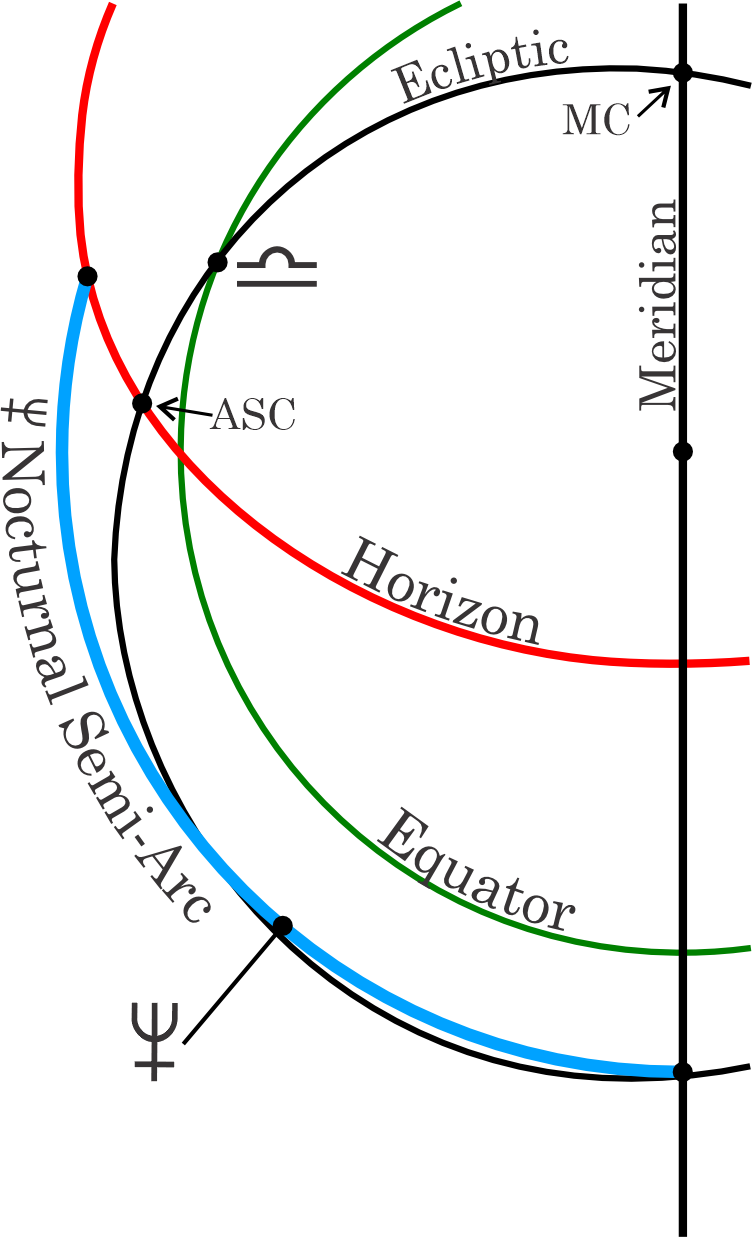 |
The path of Uranus from its rising to its culmination is called its Diurnal Semi-Arc (DSA). The path of Neptune from the IC to the Horizon is called its Nocturnal Semi-Arc (NSA). In this illustration, the Proportion of Neptune’s travel can be visualized. It is standing at .6302 of its Nocturnal Semi-Arc or 63.02% of its measurement from the Horizon to the IC.
DSA (Diurnal Semi-Arc) and NSA (Nocturnal Semi-Arc) values show the length of a planet’s arc above the Horizon. The NSA is the length of the arc below the Horizon.
When constructing the Placidus house system, the Sun’s DSA and NSA is trisected to create a standard form of Placidus Houses. If you use the DSA and NSA of other factors, you can construct Placidus houses for any specific object. One can have Mercury Placidus cusps, Venus Placidus cusps, etc. This was how the system was originally conceived. The idea of separate points of view through various house layouts set around the various planets (or even other celestial phenomena) is similar to the way personal points and auxiliary houses are used in Symmetrical Astrology. The Sun’s DSA-derived cusps commonly used today for constructing Placidus houses is a simplistic derivation of the concept.
Prop. (Proportion) is the proportion that any factor has traveled counter-clockwise on its Semi-Arc (DSA or NSA). In the table above, Neptune has a Proportion of .6302. It is expressed as a decimal part of 1 and can be understood as a percentage of the factor’s travel. In Tom Brady’s horoscope, Neptune has traveled 63.02% of the Nocturnal Semi-Arc it occupies counting from where the Semi-Arc has crossed the Horizon. This proportion is constructed from the Semi-Arc that the planet or factor in question occupies and is measured counter-clockwise from the start of the Semi-Arc in question that a planet or factor occupies. For example, if a planet or factor occupies the western Diurnal Semi-Arc, the Prop. in the Speculum table would be counted from the Horizon counter-clockwise to the factor in question and its proportion of travel would be expressed as a decimal of 1.
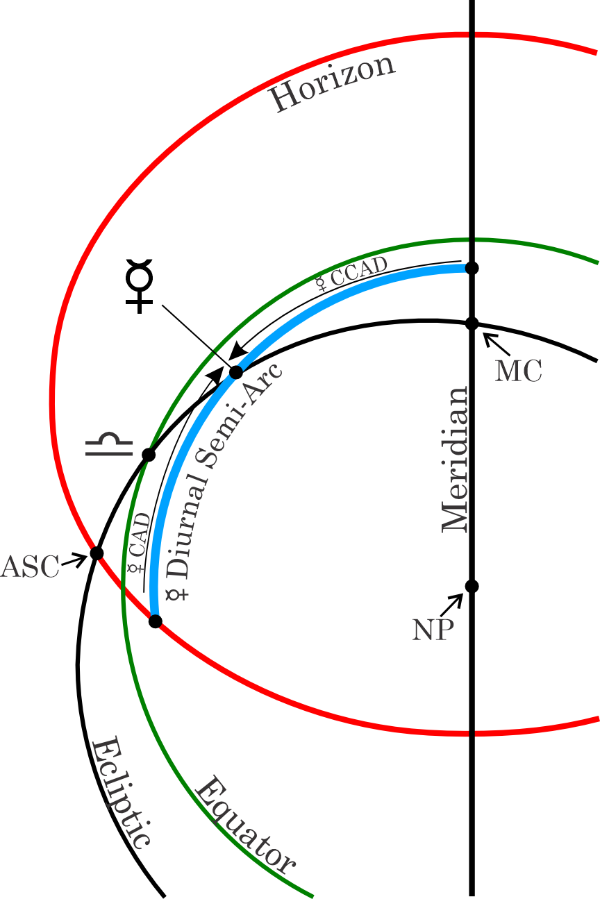
This illustration shows the Counter-Clockwise Ascensional Difference (CCAD) and the Clockwise Ascensional Difference (CAD) as measured using the position of Mercury. The Meridian is the nearest angle and measuring counter-clockwise from the Midheaven to Mercury is the CCAD, while measuring clockwise from the Horizon to Mercury is called the CAD. Note that the circle both the CCAD and the CAD make is parallel to the Equator because we use the center of the Earth (NP) to make the measurement.
CCAD and CAD are, respectively, the counter-clockwise and clockwise positions of planets measured in Ascensional and/or Descensional difference. These show the degree, measured in RAMC (right ascension of the M.C.), needed to bring a planet to an angle. In the illustration, above, Mercury is a diurnal object, above the Horizon. The distance from Mercury to the MC is called the CCAD and the distance of Mercury to the Horizon is called the CAD.
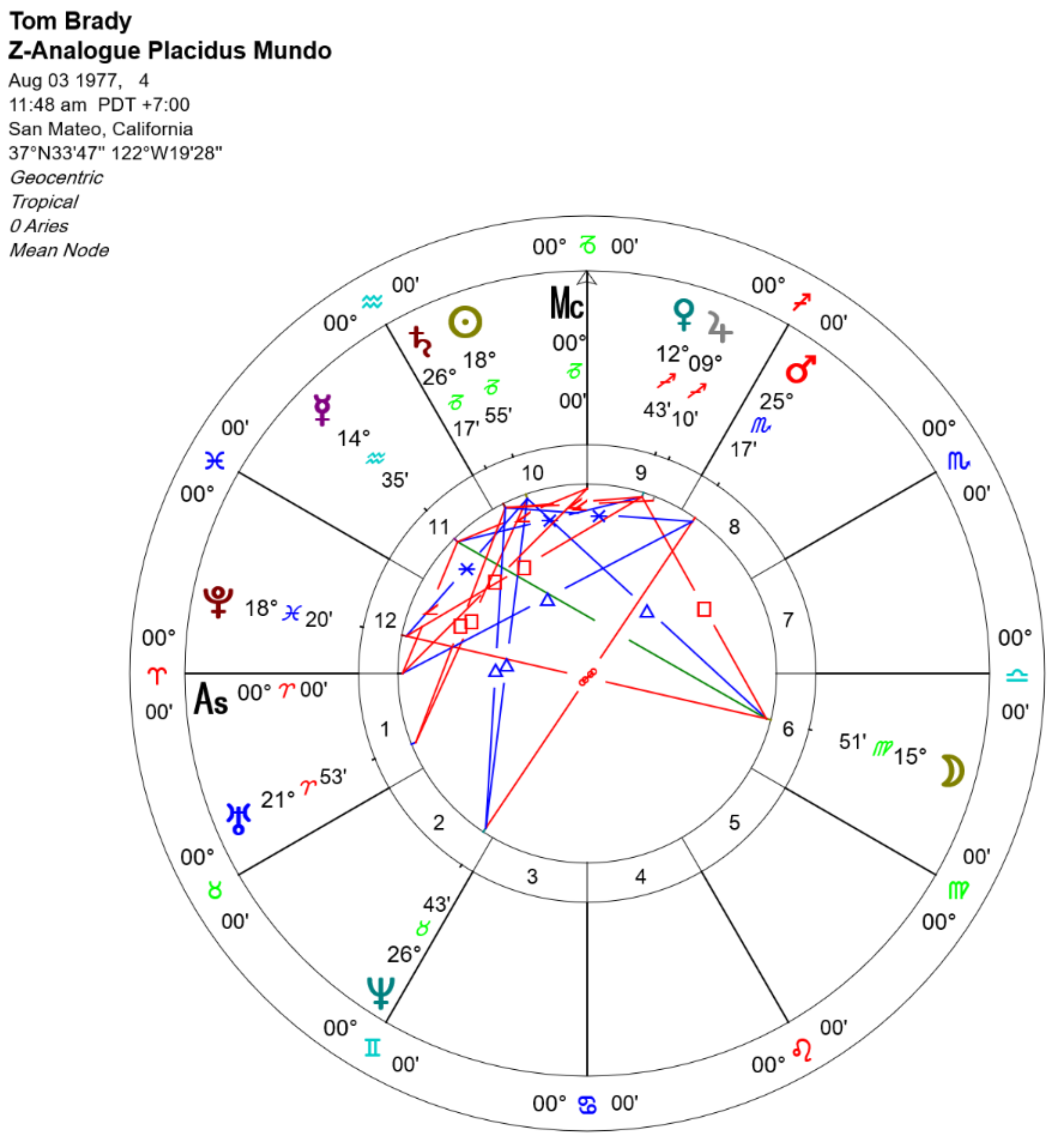
This is a Placidus Mundoscope expressed in a standard horoscope form. While this looks like a standard chart, it is only for convenience to see the material in a familiar form. The sign placements are only an analogue to represent a 360° zodiacal plane. But this format allows for in-mundo aspects and other visual material that expressing on a plane allows. You can find instructions for how to generate the various In-Mundo charts in Casting an Harmonic, Transform, Antiscia or Analogue Chart for standard style horoscopes and The Coord Button for Symmetrical Dial-style displays.
P1. Lg. Placidus Mundoscope in longitude is the planet's true position in the Placidian (semi-arc) system, expressed as a Zodiacal Analogue. Thus, a planet at 25°x17’ is near the end of the 8th Placidus house, in mundo. A planet at 18°v55’, in this listing, is a planet degree east of the upper meridian, in the 10th house. These Zodiacal Analogues should NOT be compared to planets that are actually in 25° Scorpio or 18° Capricorn in the natal chart. The sign notation is used but not the actual signs.
Astrologers have not agreed with each other as to the best way to compute mundane aspects, like mundane squares for planets in the intermediate houses. The In Mundo systems allow you to experiment to see which system (if any) gives the best results. Since the location of the intermediate cusps differ from system-to-system a square in one system may not be a square in another.
As an example reason to investigate mundane position systems would be twins born just a few minutes apart. Close twins may have quite different In Mundo aspects in their charts since these mundane contacts change so quickly, unlike aspects on the ecliptic. Despite similarities, twins are often quite different in temperament and destiny; it is unlikely that this can be shown by their ordinary ecliptic aspects. The Placidus Mundoscope uses a system that is the most similar to that used by Michel and Francoise Gauquelin in their work.
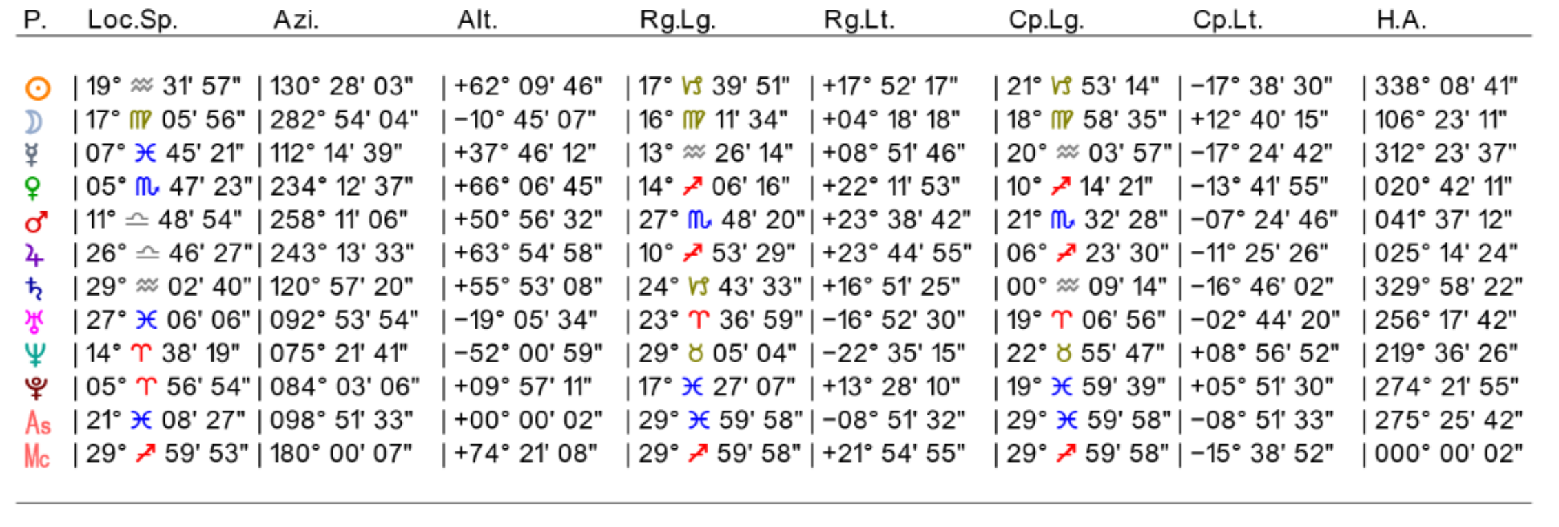
The next table in the Solar Fire Speculum shows different coordinate systems, Mundoscopes, and finishing with Hour Angles
Loc. Sp. Local Space coordinates are a Zodiacal Analogue from the East Point. One might call this style East Azimuth or the Astrological Style. A number of astrologers worked with Local Space, among them L. Edward Johndro and Michael Erlewine. This off-ecliptic chart is really an Azimuth chart. It is vastly different from the other off-ecliptic charts that are used. Local Space is a powerful local mapping tool that can be used to refine the information that you have gathered from Solar Maps in this copy of Solar Fire. See Solar Maps for a full discussion of Solar Maps and its usage. In the Solar Maps Section of Solar Fire, you can construct a Local Space chart to lay over a map of any size generated by Solar Fire.
The Local Space convention differs from other ways of measuring along the Horizon because the starting point for determining the positions of the factors is at different locations. Local Space uses the East Point (also called the Equatorial Ascendent) as a starting point and measures counter-clockwise. What we call Longitude in standard astrology is called Azimuth, but is still divides the space up via degrees, minutes and seconds of arc. Distance above or below the Horizon is called Altitude in all Horizon based systems and is expressed in degrees, minutes and seconds. Altitude uses a + symbol for above the Horizon or a – symbol for below the Horizon.
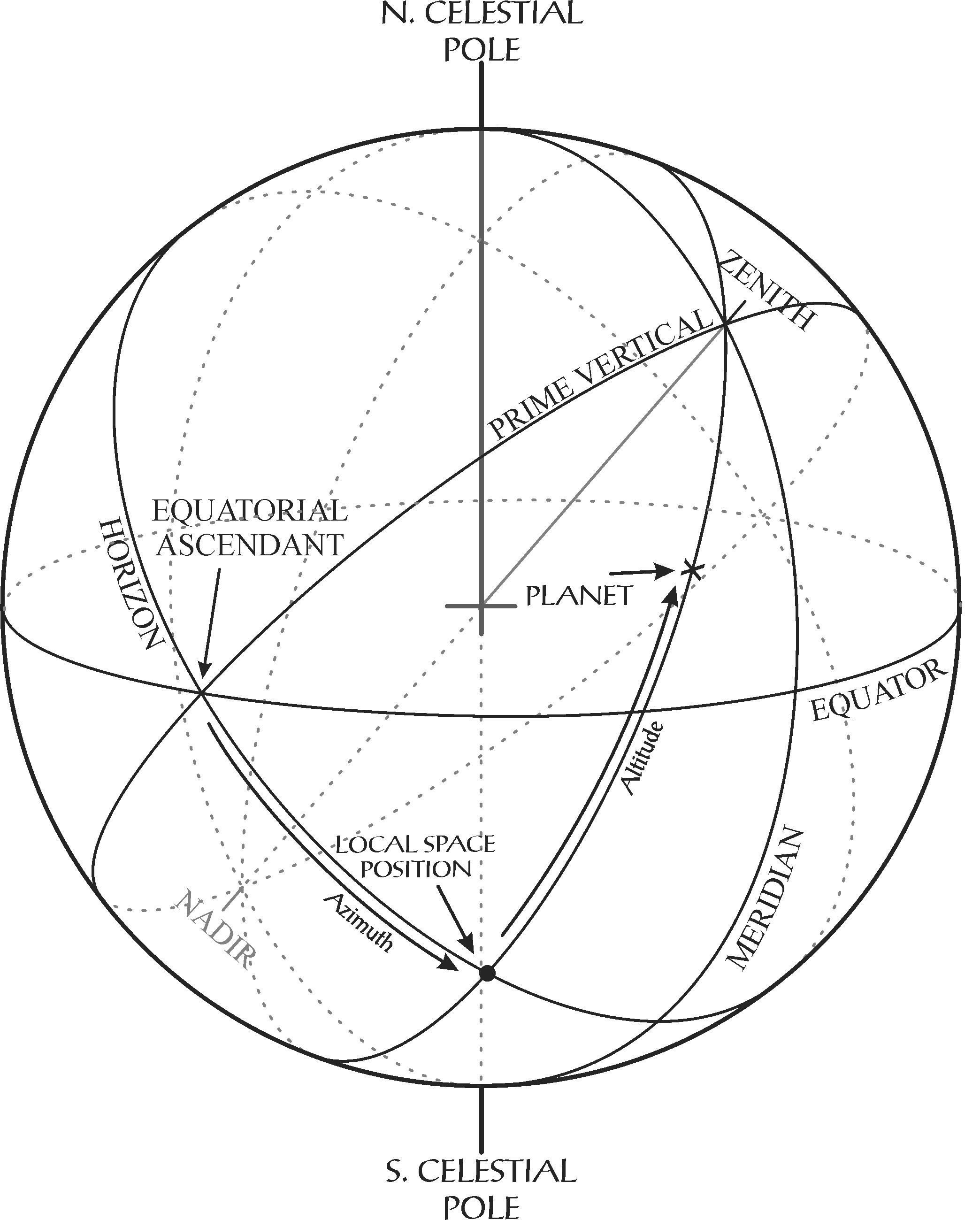
The Local Space System uses the Horizon as the fundamental plane for projecting celestial objects. The above the Horizon and below the Horizon measurement is called Altitude. The starting point for the Local Space System uses the intersection of the Prime Vertical and Horizon as its East—West starting point. This intersection is called the Equatorial Ascendant or East Point. We use the East Point as the start of measuring what is called Azimuth which is similar, but with a different name for the Longitude we use on the Zodiac and Equator. Azimuth is measured in degrees, minutes and seconds in a counter-clockwise direction. Reducing the celestial objects to the Horizon plane allows for the creation of a horoscope-like chart. The Local Space System allows the layout of celestial objects to mimic a compass and can provide directions of celestial energies or assist in horary analysis.
The Local Space Coordinates listed in the Speculum is where we use the term, Zodiacal Analogue. It is simply a convention to indicate that we are using an analogy here. These illustrations use the usual wheel chart with planets and points listed in zodiacal notation. This is for convenience since using the signs of the zodiac from the ecliptic have absolutely nothing to do with locations on any other plane, except as a familiar measuring tool. The illustrations are using the analogy of the tropical (and sidereal) zodiac as a reference frame so that you can get your bearings on the chart from any given starting point. See Casting an Harmonic, Transform, Antiscia or Analogue Chart and The Coord Button for more information.
For example, in Local Space charts, 0 degrees of Aries is an analogy for 0 degrees on the compass starting from the first degree (point) due East - the true east point of the ideal compass. Also, you will note that everything is listed in equal degree houses because this is only used as an analogy. They are only 12 30-degree segments of 360° of the compass to make the location of any given body easier to ascertain, similar to a Compass Rose.
Azi. Azimuth is a Horizon coordinate and here it is measured from the North Point and it will be familiar to navigators. In the days of steamships, it was measured from the South Point. In both cases the positions are being counted counter-clockwise. Many astrology software programs have familiarized users with Local Space as a handy system for mapping celestial positions on world and regional maps. This form of measuring Azimuth is the more formal and world known way of using this coordinate system for Navigation.
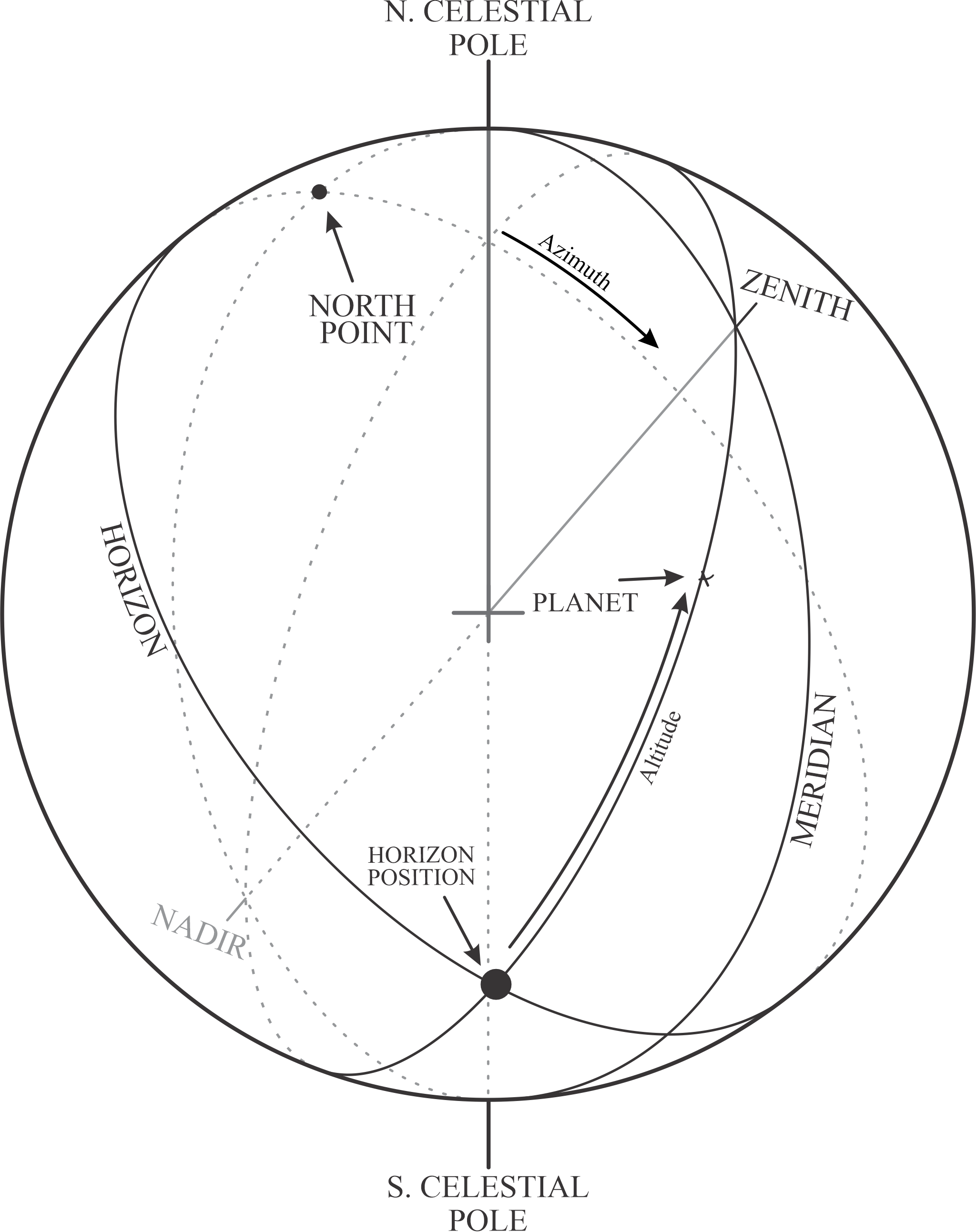
The formal Azimuth and Altitude coordinate system and how it measures a celestial object. Both this diagram and the one above are for the same object. They both show the different starting places for measuring Azimuth.
Alt. Altitude This column shows the Altitude of a planet above or below the Horizon. Expressed in degrees, and minutes and seconds with a + for above the Horizon and a – for below the Horizon, this expression of the coordinate system is common to both the Local Space and Navigational forms of expression.
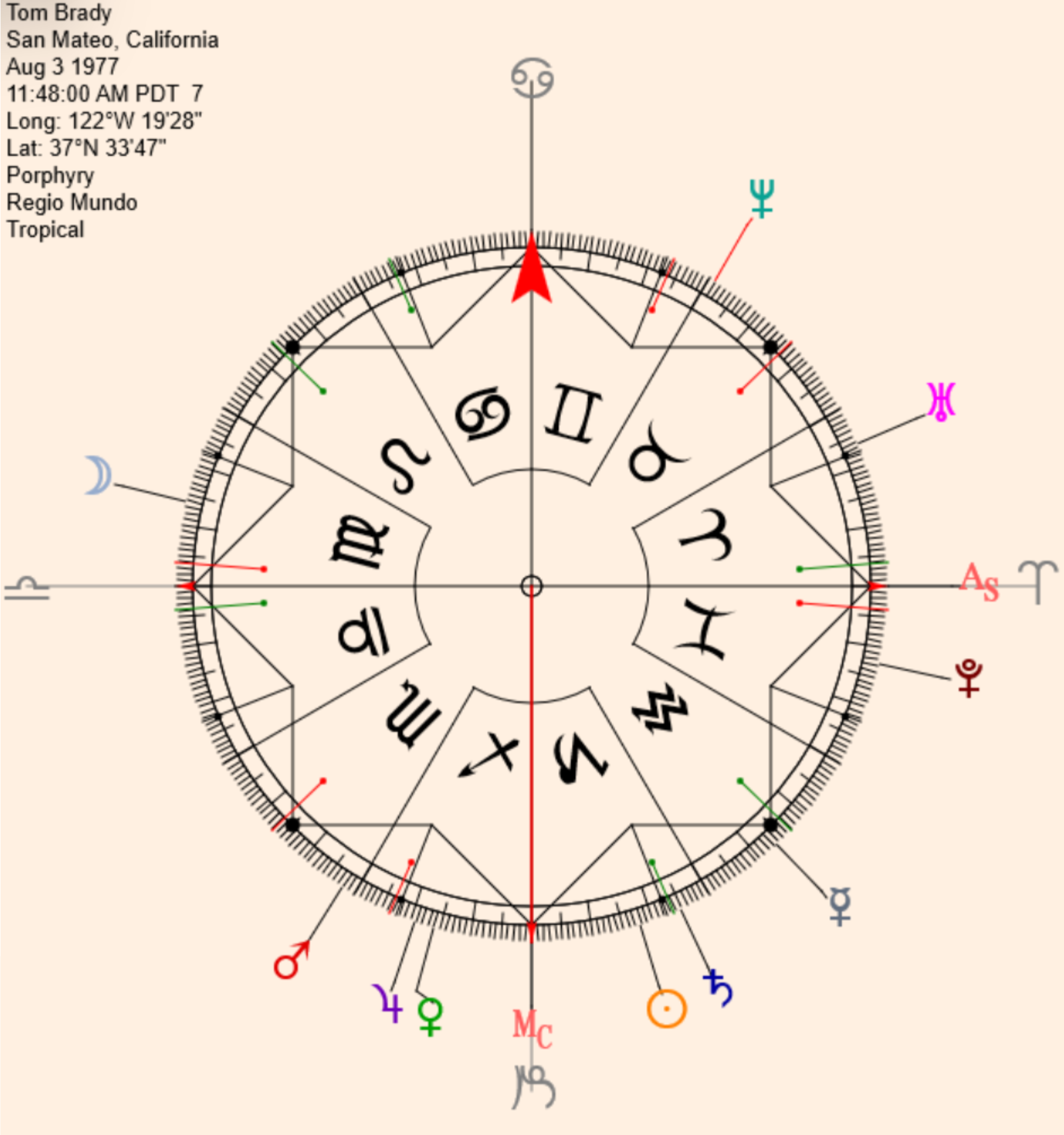
This is a Regiomontanus Mundoscope represented on a 360° Dial from the Symmetry section of Solar Fire. The use of the Dial has significant advantages over the standard horoscope form as seen above with the Placidus Mundoscope. This is an analogue chart and the planets are represented as being in zodiacal signs for convenience only. They are really represented in the Regiomontanus Houses, but are not treated as signs. There are instructions for generating the various Mundoscopes as horoscopes either using standard charts (see Casting an Harmonic, Transform, Antiscia or Analogue Chart) or as the above Symmetrical Dial view (see The Coord Button).
Rg.Lg. The Regiomontanus Mundoscope Longitude This Mundoscope allows one to see the true position of planets and factors within the Regiomontanus Houses. Naturally, this will be of particular interest to those who are interested in Regiomontanus Houses, but it will also interest those who wish to closely examine the works of astrologers like John Cadbury who used Regiomontanus "circles of position" to time directions forthcoming in the horoscopes of clients. The Regiomontanus system was used by almost all of the great European astrologers in Medieval and Renaissance times. The noted German astrologer Johannes Staffler, in 1493, made a celestial globe, now in the Germanisches Museum in Nuremberg, on which the Regiomontanus house circles were represented, in mundo, by wooden circles.
The primary reference circle of the Regiomontanus Mundoscope is the Celestial Equator. The primary reference circle of the Campanus Mundoscope is the Prime Vertical. In both of these systems the houses are semi-circles of position (or Lunes) originating from the north and south points of the horizon. Planetary position is determined by a semi-circle of position passing through the planets position in the mundane sphere and projected on the Equator (Regiomontanus) or Prime Vertical (Campanus) by right angles.
Mundoscopes (also called Analogue charts) are also discussed in The Coord Button for generating Symmetrical versions and in Casting an Harmonic, Transform, Antiscia or Analogue Chart with instructions how to generate them as standard style charts in Solar Fire.
Rg.Lt. Regiomontanus Latitude This is the orthogonal (above or below) coordinate which is paired to the Regiomontanus Longitude (Rg.Lg.). This is measured in degrees, minutes and seconds and marked with a + for above plane and with a – for below the plane.
Cp.Lg. Campanus Mundoscope Longitude This is the Campanus Mundoscope longitude position, again as a Zodiacal Analogue. Astrologers who have used this have included L. Edward Johndro, Cyril Fagan (see "AFA Research Bulletin #1"), Garth Allen, and Charles Jayne. While strongly advocated some years ago, the Campanus Mundoscope did not catch on, perhaps because the technique, like its Regiomontanus Mundoscope (Rg. Lg.) counterpart, was at that time difficult to compute by hand. Not so today with the advent of Solar Fire.
H.A. Hour Angle Students of astronomy will find this ordinate familiar. It, like Right Ascension and terrestrial longitude, is an Equatorial Coordinate and, as with RA, it is often paired with Declination. The Hour Angle can be represented in many ways. In the Solar Fire Speculum, the Hour Angle is represented by degree, minutes and seconds. The positions are measured counter-clockwise in their travel to the MC. Sometimes they are represented as time instead of degrees.
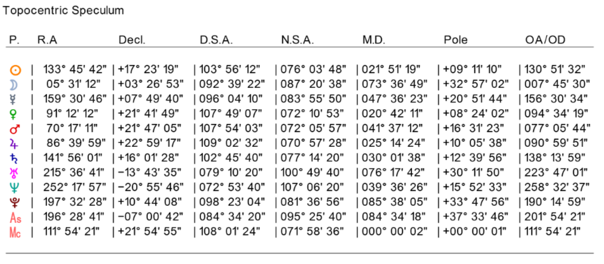
The Topographic Speculum are tables of positions used in the creation of Topocentric Houses.